Reports · Grant County, IN
Flock Cameras in Grant County: 45 on the Map, So Far
Forty-five license plate cameras are mapped inside the county line, each listed below with a link to look at its location. How the towns bought them, and what public records do and do not say, is the second report in this series; what the agencies search with them is the third. Both are coming soon.
Updated August 17, 2026
A three-part series on Flock cameras in Grant County.
- Part 1: The cameras — this report
- Part 2: The paper trail (coming soon)
- Part 3: The searches (coming soon)
What these cameras are
A license plate reader is a camera on a pole. The standard roadside units used by law enforcement are solar-powered, connect over cellular data, and need nobody to operate them.
Each camera automatically photographs passing vehicles — every one it can, whether or not the vehicle is connected to an investigation. The most common manufacturer, Flock Safety, advertises capture rates above 99 percent in good conditions. From each photograph the system stores the plate characters, the date, the time and the camera's location. It also stores a description of the vehicle — make, model, color, body type, and distinguishing features like a roof rack, a ladder in the bed, a bumper sticker, a missing hubcap, unrepaired damage. Flock markets that description as a Vehicle Fingerprint.
Flock's default was to delete reads after 30 days, on a rolling basis. On August 13, 2026 the company cut that default to seven days — but it is a recommendation and a default for new accounts, not a rule, and Flock says existing customers keep the retention periods they already have. So the change does not by itself alter anything on a Grant County camera. Retention is a contract setting, and Indiana agencies have set it differently: Fort Wayne keeps images 180 days, while South Bend and the Allen County Sheriff's Office keep 30. No Grant County agency publishes its Flock camera policies or settings, so which figure applies to the cameras here is not on any public record.
What it can be assembled into is the part residents ask about, and it is answerable from the vendor's own product descriptions and from published audit logs.
Where one plate has been. The Lookup tool returns every sighting of a specific plate over the past 1, 7, 14 or 30 days. Within an agency's own cameras that is a local history; across a sharing network it reaches much further.
A vehicle with no plate. Visual Search finds vehicles by resemblance rather than by plate, and Flock's FreeForm tool accepts a plain-language description — the company's own example is "blue SUV with a racing stripe." A plate number is not required to begin.
Who you travel with. Convoy Search returns vehicles that repeatedly appear near a given vehicle. Flock describes the output as pattern-of-life associations: regular travel companions.
An alert when you pass. The Hotlist tool notifies an agency when a listed plate is seen. All six Grant County agencies had it enabled as of September 2025, in the Pittsboro account described further down.
Everything in one place. Flock Nova combines plate data with dispatch records, records management systems, video and open-source material.
The volume matters as much as the tools. The 18 Indiana agencies that publish their own detection figures report about 685 vehicles per camera per day between them, with individual agencies ranging from 125 to 1,916. Using that 685 rate, 45 cameras would log roughly 30,800 detections a day — around 920,000 in a 30-day window, and those are detections, not unique vehicles — one commuter passing two cameras twice a day generates four of them — in a county of about 66,500 people (Census estimate, July 2025). Those figures are arithmetic on other agencies' published rates, not a measurement of ours, because ours are not published.
What that adds up to, on the arterials and the highways where these cameras sit, is a record of the vehicles that passed them, when, in which direction, and — where one is captured repeatedly — a pattern in its movement.
Flock's retention policy, last updated January 9, 2026, adds a step worth knowing about here: if an agency wants to keep data longer than 30 days and its own state law does not already require it, Flock says it will extend retention up to one year only after the agency obtains approval from an elected official or a governing body. So a Grant County agency keeping images past 30 days would, by the vendor's own rule, have needed that approval first. The August 2026 announcement did not address that step, and no Grant County board has a camera retention vote in its minutes.
How common this is
Flock told The New York Times in August 2026 that it runs about 120,000 cameras, in every state except Alaska, under contracts with 7,000 law enforcement agencies — 40 percent of the police departments in the country, by the Times' count.
Cities and agencies are canceling Flock
In July 2026 the Los Angeles Police Department let its three-year Flock contract expire. Its chief information officer, Dean Gialamas, told TechCrunch why: “This contract is not being renewed because of serious concerns around civil liberties and civil rights issues, particularly around privacy and the data that is being collected from these cameras.” He said the department was “discontinuing using Flock services until we can get those data, privacy, security and sharing concerns ironed out through a contractual relationship.”
Smaller places have made the same call, and the count is moving fast. On August 3, 2026 the Washington Examiner put it at about 23 city councils since January 2026 and roughly 98 since 2021 — among them Harrisonburg and Elkton in Virginia, Framingham, Massachusetts, and Saranac Lake, New York. Eleven days later, on August 14, Stateline reported the 2026 figure at more than 50 agencies or communities, in cities across 23 states. Both numbers come from the same DeFlock tally; it more than doubled inside two weeks. DeFlock is also the group behind the camera map this report links to, so it is both the mapmaker and the scorekeeper here, and nobody outside it audits either figure.
Nothing like that has come to a vote here. None of the minutes Grant County's four boards publish records a vote to cancel a Flock contract, reject a camera or switch one off. The cameras are still up, and where they stand is the rest of this report.
The map below is volunteers' work, from OpenStreetMap, and it is incomplete: eight of the first 39 were added in the week before this report was published, and six more went on the map on August 16, 2026 — added by OurWeek, five of them inside Matter Park and one on North Washington Street. Where this report counts cameras, six of the 45 are our own entries, and we say so rather than cite the map as though it were somebody else's tally. Four carry a tag naming a retailer and the other 41 carry no operator tag at all, so it does not say who reads most of this data. Read 45 as a floor.
DeFlock map of Grant County
Open it on DeFlockWhere they are
Two patterns.
Inside Marion, they sit on the streets that carry the city's traffic — Wabash and Spencer avenues, the numbered east–west streets from 9th to 38th, Boots, Gallatin, Western, Ivanhoe, River Drive, and the Riverwalk at Matter Park. Two of the Wabash Avenue nodes sit near Marion Health.
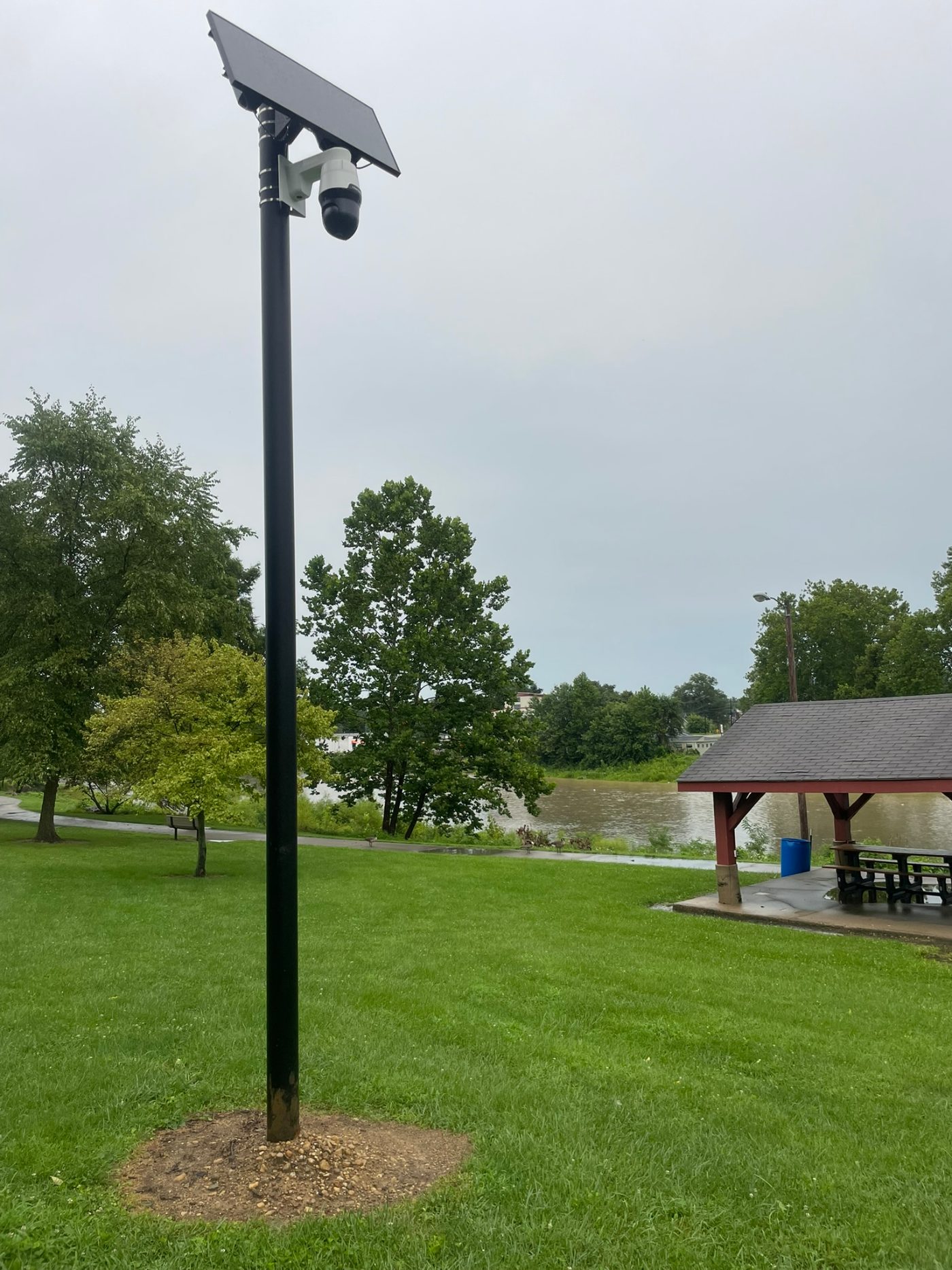
One of the River Drive nodes is not a plate reader on a roadside pole. It stands on its own solar-powered mast in the lawn along the Mississinewa Riverwalk in Marion. A public picnic shelter stands within its line of sight — OurWeek photographed the camera from underneath that shelter on August 11, 2026, with the camera lens in frame.
The housing is not the flat roadside box. It is a white unit with a black head that turns, mounted beside its solar panel. The housing carries a Flock Safety label.
It points into the shelter. OurWeek also observed it facing the path rather than the street on August 6 and August 8. The unit pans, so that is not necessarily a permanent setting.
Flock's plate reader looks nothing like this unit, and the line of Flock's products that matches this housing does live video and audio as well as plate reads. Which of the company's models this is has not been established — no record in Marion's files describes it, and neither the city nor the company has been asked on the record. What it records of people on foot is not established either.
Outside the city, cameras sit on numbered routes near the county's edges. Twenty-one of the 39 mapped before this month are within 270 yards of a state or federal route: seven near SR 18, seven near SR 9, six near US 35, five near SR 22, five near SR 15, four near SR 13 and two near I-69 — a camera close to two routes counts under both, so those figures overlap rather than sum. Several sit at county-road crossings: Strawtown Pike, North Huntington Road, East North 00 South, 900 South.
The arterials inside town, and the highways in and out — and, since August 16, a public park. Five of the six newest cameras stand inside Matter Park, aimed at the playground, the gardens, a picnic pavilion, the pickleball courts and a disc golf hole rather than at a road; what each one faces is the subject of a separate report. Every one of the 45 is in the table below, with a link to view its location in Google Street View.
East 18th Street & South Florence Street & South McClure Street
Marion · — · 2026-07-17
Imagery is dated and the view is where a camera was found, not proof one is there today. Open it in Google Maps →
Clark Street & East 30th Street & South Home Avenue
Marion · — · 2025-12-10
Imagery is dated and the view is where a camera was found, not proof one is there today. Open it in Google Maps →
East 38th Street & South Home Avenue & South Lincoln Boulevard
Marion · — · 2025-11-18
Imagery is dated and the view is where a camera was found, not proof one is there today. Open it in Google Maps →
East State Road 18
Marion · SR 18 · 2025-09-17
Imagery is dated and the view is where a camera was found, not proof one is there today. Open it in Google Maps →
North High Street & North Locust Street & North Wabash Avenue
Marion · — · 2025-10-04
Imagery is dated and the view is where a camera was found, not proof one is there today. Open it in Google Maps →
North River Drive & North Wabash Avenue & West Spencer Avenue
Marion · — · 2026-05-04
Imagery is dated and the view is where a camera was found, not proof one is there today. Open it in Google Maps →
South Boots Street & West 10th Street
Marion · — · 2026-08-07
Imagery is dated and the view is where a camera was found, not proof one is there today. Open it in Google Maps →
South Nebraska Street & West 2nd Street & West 3rd Street
Marion · SR 18 · 2026-05-15
Imagery is dated and the view is where a camera was found, not proof one is there today. Open it in Google Maps →
East 33rd Street & East 34th Street & South Boots Street
Marion · — · 2026-06-09
Imagery is dated and the view is where a camera was found, not proof one is there today. Open it in Google Maps →
South D Street & West 10th Street
Marion · — · 2026-08-06
Imagery is dated and the view is where a camera was found, not proof one is there today. Open it in Google Maps →
South Gallatin Street & West 10th Street
Marion · — · 2026-08-07
Imagery is dated and the view is where a camera was found, not proof one is there today. Open it in Google Maps →
South 800 West & West 500 S & West 500 South
Marion · SR 13, SR 19, SR 22, US 35 · 2025-09-17
Imagery is dated and the view is where a camera was found, not proof one is there today. Open it in Google Maps →
South Michigan Avenue & West 9th Street
Marion · — · 2025-09-25
Imagery is dated and the view is where a camera was found, not proof one is there today. Open it in Google Maps →
Greentree Drive & West Spencer Avenue
Marion · — · 2026-08-06
Imagery is dated and the view is where a camera was found, not proof one is there today. Open it in Google Maps →
900 South
Fairmount · SR 26 · 2025-09-17
Imagery is dated and the view is where a camera was found, not proof one is there today. Open it in Google Maps →
North Main Street & South 150 East
Fairmount · — · 2026-02-19
Imagery is dated and the view is where a camera was found, not proof one is there today. Open it in Google Maps →
Beaner Boulevard & East 500 South
Gas City · SR 22, US 35 · 2025-03-25
Imagery is dated and the view is where a camera was found, not proof one is there today. Open it in Google Maps →
East Hi Way Drive — east
Gas City · SR 22, US 35 · 2025-09-17
Imagery is dated and the view is where a camera was found, not proof one is there today. Open it in Google Maps →
East Hi Way Drive — west
Gas City · SR 22, US 35 · 2025-09-17
Imagery is dated and the view is where a camera was found, not proof one is there today. Open it in Google Maps →
South 500 W & South Main Street & West North 00 S
Sweetser · — · 2025-09-25
Imagery is dated and the view is where a camera was found, not proof one is there today. Open it in Google Maps →
East North 00 South & Love's Travel Stop
Dooville · I 69, SR 18 · 2025-09-19
Imagery is dated and the view is where a camera was found, not proof one is there today. Open it in Google Maps →
North Wabash Road
Fox · SR 15 · 2026-07-27
Imagery is dated and the view is where a camera was found, not proof one is there today. Open it in Google Maps →
East North 00 South
Friendly Corner · SR 18, SR 5 · 2025-09-17
Imagery is dated and the view is where a camera was found, not proof one is there today. Open it in Google Maps →
East 600 North & North Huntington Road
Limb Town · SR 9 · 2025-09-17
Imagery is dated and the view is where a camera was found, not proof one is there today. Open it in Google Maps →
East Marion Street
Mier · SR 13, SR 18 · 2025-09-17
Imagery is dated and the view is where a camera was found, not proof one is there today. Open it in Google Maps →
Strawtown Pike & West County Road 900 South
Rigdon · SR 26, SR 37 · 2025-05-01
Imagery is dated and the view is where a camera was found, not proof one is there today. Open it in Google Maps →
East North 00 South & North 1200 East; North 400 West & South 1200 East; North 400 West
Unincorporated · SR 18 · 2025-11-17
Imagery is dated and the view is where a camera was found, not proof one is there today. Open it in Google Maps →
South East 00 West
Unincorporated · SR 9 · 2025-09-17
Imagery is dated and the view is where a camera was found, not proof one is there today. Open it in Google Maps →
900 East & South 300 West & West 1200 South; East 700 North
Unincorporated · I 69, SR 5 · 2025-06-16
Imagery is dated and the view is where a camera was found, not proof one is there today. Open it in Google Maps →
East Charles Street & North Cassius Street & North Meridian Street
Marion · — · 2026-06-17
No camera visible in Street View
This is the mapped point and the nearest imagery Google has. Nobody has found the camera in it, which says nothing about what is on the pole — the imagery is dated, and a camera can sit outside the frame. Open it in Google Maps →
Mississinewa Riverwalk & North Matter Park Road
Marion · SR 9 · 2026-08-08
No camera visible in Street View
This is the mapped point and the nearest imagery Google has. Nobody has found the camera in it, which says nothing about what is on the pole — the imagery is dated, and a camera can sit outside the frame. Open it in Google Maps →
North Ivanhoe Drive
Marion · — · 2026-08-04
No camera visible in Street View
This is the mapped point and the nearest imagery Google has. Nobody has found the camera in it, which says nothing about what is on the pole — the imagery is dated, and a camera can sit outside the frame. Open it in Google Maps →
North River Drive
Marion · — · 2026-08-08
South Valley Avenue — north
Marion · SR 15, SR 9 · Lowe's · 2026-05-22
No camera visible in Street View
This is the mapped point and the nearest imagery Google has. Nobody has found the camera in it, which says nothing about what is on the pole — the imagery is dated, and a camera can sit outside the frame. Open it in Google Maps →
South Valley Avenue — middle
Marion · SR 15, SR 9 · Lowe's · 2026-05-23
No camera visible in Street View
This is the mapped point and the nearest imagery Google has. Nobody has found the camera in it, which says nothing about what is on the pole — the imagery is dated, and a camera can sit outside the frame. Open it in Google Maps →
South Valley Avenue — south
Marion · SR 15, SR 9 · Lowe's · 2026-05-22
No camera visible in Street View
This is the mapped point and the nearest imagery Google has. Nobody has found the camera in it, which says nothing about what is on the pole — the imagery is dated, and a camera can sit outside the frame. Open it in Google Maps →
South Western Avenue
Marion · SR 15, SR 9 · Lowe's · 2026-05-22
No camera visible in Street View
This is the mapped point and the nearest imagery Google has. Nobody has found the camera in it, which says nothing about what is on the pole — the imagery is dated, and a camera can sit outside the frame. Open it in Google Maps →
South Gallatin Street & West 23rd Street
Marion · — · 2026-08-03
No camera visible in Street View
This is the mapped point and the nearest imagery Google has. Nobody has found the camera in it, which says nothing about what is on the pole — the imagery is dated, and a camera can sit outside the frame. Open it in Google Maps →
200 N & North 500 W
Unincorporated · — · 2025-09-18
No camera visible in Street View
This is the mapped point and the nearest imagery Google has. Nobody has found the camera in it, which says nothing about what is on the pole — the imagery is dated, and a camera can sit outside the frame. Open it in Google Maps →
Matter Park — north end, facing south
Marion · — · 2026-08-16
No camera visible in Street View
This is the mapped point and the nearest imagery Google has. Nobody has found the camera in it, which says nothing about what is on the pole — the imagery is dated, and a camera can sit outside the frame. Open it in Google Maps →
Matter Park — playground, facing east
Marion · — · 2026-08-16
No camera visible in Street View
This is the mapped point and the nearest imagery Google has. Nobody has found the camera in it, which says nothing about what is on the pole — the imagery is dated, and a camera can sit outside the frame. Open it in Google Maps →
Matter Park — gardens, facing south
Marion · — · 2026-08-16
No camera visible in Street View
This is the mapped point and the nearest imagery Google has. Nobody has found the camera in it, which says nothing about what is on the pole — the imagery is dated, and a camera can sit outside the frame. Open it in Google Maps →
Matter Park — south end, facing west
Marion · — · 2026-08-16
No camera visible in Street View
This is the mapped point and the nearest imagery Google has. Nobody has found the camera in it, which says nothing about what is on the pole — the imagery is dated, and a camera can sit outside the frame. Open it in Google Maps →
Matter Park — south end, facing east
Marion · — · 2026-08-16
No camera visible in Street View
This is the mapped point and the nearest imagery Google has. Nobody has found the camera in it, which says nothing about what is on the pole — the imagery is dated, and a camera can sit outside the frame. Open it in Google Maps →
North Washington Street
Marion · — · 2026-08-16
No camera visible in Street View
This is the mapped point and the nearest imagery Google has. Nobody has found the camera in it, which says nothing about what is on the pole — the imagery is dated, and a camera can sit outside the frame. Open it in Google Maps →
| Area | At or near | Route | Operator tag | First mapped | Look at it |
|---|---|---|---|---|---|
| Marion | East 18th Street & South Florence Street & South McClure Street | — | 2026-07-17 | ||
Imagery is dated and the view is where a camera was found, not proof one is there today. Open it in Google Maps → | |||||
| Marion | Clark Street & East 30th Street & South Home Avenue | — | 2025-12-10 | ||
Imagery is dated and the view is where a camera was found, not proof one is there today. Open it in Google Maps → | |||||
| Marion | East 38th Street & South Home Avenue & South Lincoln Boulevard | — | 2025-11-18 | ||
Imagery is dated and the view is where a camera was found, not proof one is there today. Open it in Google Maps → | |||||
| Marion | East State Road 18 | SR 18 | 2025-09-17 | ||
Imagery is dated and the view is where a camera was found, not proof one is there today. Open it in Google Maps → | |||||
| Marion | North High Street & North Locust Street & North Wabash Avenue | — | 2025-10-04 | ||
Imagery is dated and the view is where a camera was found, not proof one is there today. Open it in Google Maps → | |||||
| Marion | North River Drive & North Wabash Avenue & West Spencer Avenue | — | 2026-05-04 | ||
Imagery is dated and the view is where a camera was found, not proof one is there today. Open it in Google Maps → | |||||
| Marion | South Boots Street & West 10th Street | — | 2026-08-07 | ||
Imagery is dated and the view is where a camera was found, not proof one is there today. Open it in Google Maps → | |||||
| Marion | South Nebraska Street & West 2nd Street & West 3rd Street | SR 18 | 2026-05-15 | ||
Imagery is dated and the view is where a camera was found, not proof one is there today. Open it in Google Maps → | |||||
| Marion | East 33rd Street & East 34th Street & South Boots Street | — | 2026-06-09 | ||
Imagery is dated and the view is where a camera was found, not proof one is there today. Open it in Google Maps → | |||||
| Marion | South D Street & West 10th Street | — | 2026-08-06 | ||
Imagery is dated and the view is where a camera was found, not proof one is there today. Open it in Google Maps → | |||||
| Marion | South Gallatin Street & West 10th Street | — | 2026-08-07 | ||
Imagery is dated and the view is where a camera was found, not proof one is there today. Open it in Google Maps → | |||||
| Marion | South 800 West & West 500 S & West 500 South | SR 13, SR 19, SR 22, US 35 | 2025-09-17 | ||
Imagery is dated and the view is where a camera was found, not proof one is there today. Open it in Google Maps → | |||||
| Marion | South Michigan Avenue & West 9th Street | — | 2025-09-25 | ||
Imagery is dated and the view is where a camera was found, not proof one is there today. Open it in Google Maps → | |||||
| Marion | Greentree Drive & West Spencer Avenue | — | 2026-08-06 | ||
Imagery is dated and the view is where a camera was found, not proof one is there today. Open it in Google Maps → | |||||
| Fairmount | 900 South | SR 26 | 2025-09-17 | ||
Imagery is dated and the view is where a camera was found, not proof one is there today. Open it in Google Maps → | |||||
| Fairmount | North Main Street & South 150 East | — | 2026-02-19 | ||
Imagery is dated and the view is where a camera was found, not proof one is there today. Open it in Google Maps → | |||||
| Gas City | Beaner Boulevard & East 500 South | SR 22, US 35 | 2025-03-25 | ||
Imagery is dated and the view is where a camera was found, not proof one is there today. Open it in Google Maps → | |||||
| Gas City | East Hi Way Drive — east | SR 22, US 35 | 2025-09-17 | ||
Imagery is dated and the view is where a camera was found, not proof one is there today. Open it in Google Maps → | |||||
| Gas City | East Hi Way Drive — west | SR 22, US 35 | 2025-09-17 | ||
Imagery is dated and the view is where a camera was found, not proof one is there today. Open it in Google Maps → | |||||
| Sweetser | South 500 W & South Main Street & West North 00 S | — | 2025-09-25 | ||
Imagery is dated and the view is where a camera was found, not proof one is there today. Open it in Google Maps → | |||||
| Dooville | East North 00 South & Love's Travel Stop | I 69, SR 18 | 2025-09-19 | ||
Imagery is dated and the view is where a camera was found, not proof one is there today. Open it in Google Maps → | |||||
| Fox | North Wabash Road | SR 15 | 2026-07-27 | ||
Imagery is dated and the view is where a camera was found, not proof one is there today. Open it in Google Maps → | |||||
| Friendly Corner | East North 00 South | SR 18, SR 5 | 2025-09-17 | ||
Imagery is dated and the view is where a camera was found, not proof one is there today. Open it in Google Maps → | |||||
| Limb Town | East 600 North & North Huntington Road | SR 9 | 2025-09-17 | ||
Imagery is dated and the view is where a camera was found, not proof one is there today. Open it in Google Maps → | |||||
| Mier | East Marion Street | SR 13, SR 18 | 2025-09-17 | ||
Imagery is dated and the view is where a camera was found, not proof one is there today. Open it in Google Maps → | |||||
| Rigdon | Strawtown Pike & West County Road 900 South | SR 26, SR 37 | 2025-05-01 | ||
Imagery is dated and the view is where a camera was found, not proof one is there today. Open it in Google Maps → | |||||
| Unincorporated | East North 00 South & North 1200 East; North 400 West & South 1200 East; North 400 West | SR 18 | 2025-11-17 | ||
Imagery is dated and the view is where a camera was found, not proof one is there today. Open it in Google Maps → | |||||
| Unincorporated | South East 00 West | SR 9 | 2025-09-17 | ||
Imagery is dated and the view is where a camera was found, not proof one is there today. Open it in Google Maps → | |||||
| Unincorporated | 900 East & South 300 West & West 1200 South; East 700 North | I 69, SR 5 | 2025-06-16 | ||
Imagery is dated and the view is where a camera was found, not proof one is there today. Open it in Google Maps → | |||||
| Marion | East Charles Street & North Cassius Street & North Meridian Street | — | 2026-06-17 | ||
No camera visible in Street View This is the mapped point and the nearest imagery Google has. Nobody has found the camera in it, which says nothing about what is on the pole — the imagery is dated, and a camera can sit outside the frame. Open it in Google Maps → | |||||
| Marion | Mississinewa Riverwalk & North Matter Park Road | SR 9 | 2026-08-08 | ||
No camera visible in Street View This is the mapped point and the nearest imagery Google has. Nobody has found the camera in it, which says nothing about what is on the pole — the imagery is dated, and a camera can sit outside the frame. Open it in Google Maps → | |||||
| Marion | North Ivanhoe Drive | — | 2026-08-04 | ||
No camera visible in Street View This is the mapped point and the nearest imagery Google has. Nobody has found the camera in it, which says nothing about what is on the pole — the imagery is dated, and a camera can sit outside the frame. Open it in Google Maps → | |||||
| Marion | North River Drive | — | 2026-08-08 | ||
| Marion | South Valley Avenue — north | SR 15, SR 9 | Lowe's | 2026-05-22 | |
No camera visible in Street View This is the mapped point and the nearest imagery Google has. Nobody has found the camera in it, which says nothing about what is on the pole — the imagery is dated, and a camera can sit outside the frame. Open it in Google Maps → | |||||
| Marion | South Valley Avenue — middle | SR 15, SR 9 | Lowe's | 2026-05-23 | |
No camera visible in Street View This is the mapped point and the nearest imagery Google has. Nobody has found the camera in it, which says nothing about what is on the pole — the imagery is dated, and a camera can sit outside the frame. Open it in Google Maps → | |||||
| Marion | South Valley Avenue — south | SR 15, SR 9 | Lowe's | 2026-05-22 | |
No camera visible in Street View This is the mapped point and the nearest imagery Google has. Nobody has found the camera in it, which says nothing about what is on the pole — the imagery is dated, and a camera can sit outside the frame. Open it in Google Maps → | |||||
| Marion | South Western Avenue | SR 15, SR 9 | Lowe's | 2026-05-22 | |
No camera visible in Street View This is the mapped point and the nearest imagery Google has. Nobody has found the camera in it, which says nothing about what is on the pole — the imagery is dated, and a camera can sit outside the frame. Open it in Google Maps → | |||||
| Marion | South Gallatin Street & West 23rd Street | — | 2026-08-03 | ||
No camera visible in Street View This is the mapped point and the nearest imagery Google has. Nobody has found the camera in it, which says nothing about what is on the pole — the imagery is dated, and a camera can sit outside the frame. Open it in Google Maps → | |||||
| Unincorporated | 200 N & North 500 W | — | 2025-09-18 | ||
No camera visible in Street View This is the mapped point and the nearest imagery Google has. Nobody has found the camera in it, which says nothing about what is on the pole — the imagery is dated, and a camera can sit outside the frame. Open it in Google Maps → | |||||
| Marion | Matter Park — north end, facing south | — | 2026-08-16 | ||
No camera visible in Street View This is the mapped point and the nearest imagery Google has. Nobody has found the camera in it, which says nothing about what is on the pole — the imagery is dated, and a camera can sit outside the frame. Open it in Google Maps → | |||||
| Marion | Matter Park — playground, facing east | — | 2026-08-16 | ||
No camera visible in Street View This is the mapped point and the nearest imagery Google has. Nobody has found the camera in it, which says nothing about what is on the pole — the imagery is dated, and a camera can sit outside the frame. Open it in Google Maps → | |||||
| Marion | Matter Park — gardens, facing south | — | 2026-08-16 | ||
No camera visible in Street View This is the mapped point and the nearest imagery Google has. Nobody has found the camera in it, which says nothing about what is on the pole — the imagery is dated, and a camera can sit outside the frame. Open it in Google Maps → | |||||
| Marion | Matter Park — south end, facing west | — | 2026-08-16 | ||
No camera visible in Street View This is the mapped point and the nearest imagery Google has. Nobody has found the camera in it, which says nothing about what is on the pole — the imagery is dated, and a camera can sit outside the frame. Open it in Google Maps → | |||||
| Marion | Matter Park — south end, facing east | — | 2026-08-16 | ||
No camera visible in Street View This is the mapped point and the nearest imagery Google has. Nobody has found the camera in it, which says nothing about what is on the pole — the imagery is dated, and a camera can sit outside the frame. Open it in Google Maps → | |||||
| Marion | North Washington Street | — | 2026-08-16 | ||
No camera visible in Street View This is the mapped point and the nearest imagery Google has. Nobody has found the camera in it, which says nothing about what is on the pole — the imagery is dated, and a camera can sit outside the frame. Open it in Google Maps → | |||||
Rows are OpenStreetMap nodes tagged man_made=surveillance with surveillance:type=ALPR, retrieved at the time given in the sources below. “At or near” lists the named roads within 90 meters, so it locates an area about that wide rather than a pole. “Operator tag” is what a mapper recorded, not a confirmed contract; only four carry one, all in the same retail area off SR 9/SR 15. The three South Valley Avenue rows, and Gas City's two on East Hi Way Drive, are separate poles rather than repeats — 20 to 110 meters apart, each with its own direction tag — and are listed north to south and east to west. The list is in two parts. The first 29 are aimed: we opened the panorama, found the camera, and both the link and the panel open on that capture. The last 16 sit at the end marked “Location only” — their panels open on the nearest imagery to the mapped point and say on the frame that no camera is visible in it, which says nothing about what is on the pole. One of those, the mast on North River Drive, shows our own photograph instead, because Street View has nothing useful there. Street View imagery is usually older than the map entry, so it is a look at the place rather than evidence about a camera today, and “First mapped” dates a volunteer's entry rather than an installation. The six rows dated August 16, 2026 are OurWeek's own map entries, made after we found the cameras in the park and on the street; they are located by the park or street they stand in rather than by the 90-meter road pass the other 39 got, and none has been photographed for this table yet. Read 45 as a floor.
A records request from 64 miles away
Grant County's agencies do not publish their Flock camera inventory. The numbers above come from somewhere else entirely.
In September 2025 the Electronic Frontier Foundation filed a public records request with the Pittsboro Police Department, in Hendricks County on the far side of Indianapolis, 64 miles from Marion. That document is public: the Flock Safety shared-devices list obtained from the Pittsboro Police Department runs 930 pages and lists roughly 4,000 networks, and we keep our own copy of it. Pittsboro had a Flock Safety account, and because other agencies were sharing their camera data with Pittsboro, Pittsboro's own console held a list of those agencies and how many cameras each one ran. Seven of its lines are ours: six agencies and 37 cameras, counted a year before the map was. Marion has two lines because its two portable cameras sit on a separate account.
“Search: Enabled” is what the Pittsboro Police Department's Flock account held for every one of those lines as of September 2025. That is also the only reason the counts above are public: our camera numbers reached the public record through another department's paperwork, not our own.
One more thing about Pittsboro is worth noting, because it is the mirror image of the situation here. Pittsboro publishes a Flock transparency page. On August 10, 2026 it reported 13 cameras and 104,411 vehicles detected in a 30-day window, about 268 per camera per day; the page updates, so expect different figures. A resident of Pittsboro can look that up. A resident of Grant County cannot look up the equivalent for any of the six agencies above.
Who filed it, and why a small department's paperwork names Grant County
The Electronic Frontier Foundation is a civil-liberties nonprofit that runs a standing public-records operation on police technology. Its Atlas of Surveillance catalogs which departments use which tools, agency by agency, and it is built by filing public records requests in bulk — hundreds of them, with students and volunteers processing what comes back. This 930-page list is one document out of that effort. Neither EFF's posting of it nor anything published since says why Pittsboro in particular was asked, so we are not going to guess at a reason.
What makes any one department's list worth having is that the sharing is reciprocal. A department that wants to search other agencies' cameras has to share access to its own — Flock's chief executive confirmed that arrangement to The New York Times. So a roster of who shares with one department doubles as a roster of what that department can search. EFF's own description of this document says almost 4,000 agencies were sharing plate-reader data with Pittsboro, and that Pittsboro therefore held a record of all of those agencies' camera networks. That is how a town of 3,682 people comes to hold the paperwork that names six Grant County agencies.
EFF has put the same gap in numbers elsewhere: it counts more than 1,800 agencies as having deployed plate readers, while at least 4,000 can run searches through agencies in Flock's network.
The shared-devices list covers agencies and nothing else. Four of the mapped cameras here carry a tag naming a retailer rather than a police department, and a privately owned camera sits outside that list entirely — so whether those four feed anything an agency can search is not established either way. A tag entered by a volunteer records who a mapper took to be the owner. It does not record who can run a query.
Marion IN PD · 14 · Enabled · Disabled · Enabled
Marion IN PD (FLEX) · 2 · Enabled · Disabled · Enabled
Grant County IN SO · 11 · Enabled · Disabled · Enabled
Sweetser PD IN · 4 · Enabled · Disabled · Enabled
Gas City IN PD · 2 · Enabled · Disabled · Enabled
Fairmount IN PD · 2 · Enabled · Disabled · Enabled
Marion Health PD (IN) · 2 · Enabled · Disabled · Enabled
| As listed in the document | Cameras | Search | Device Mgmt | Hotlist Tool | See the page |
|---|---|---|---|---|---|
| Marion IN PD | 14 | Enabled | Disabled | Enabled | |
| Marion IN PD (FLEX) | 2 | Enabled | Disabled | Enabled | |
| Grant County IN SO | 11 | Enabled | Disabled | Enabled | |
| Sweetser PD IN | 4 | Enabled | Disabled | Enabled | |
| Gas City IN PD | 2 | Enabled | Disabled | Enabled | |
| Fairmount IN PD | 2 | Enabled | Disabled | Enabled | |
| Marion Health PD (IN) | 2 | Enabled | Disabled | Enabled |
37 cameras at six agencies. Marion has two lines because its portable cameras sit on a separate account. Tap a row to open the page of the shared-devices list that line is listed on, with its line boxed, alongside the document itself and the Electronic Frontier Foundation's original on DocumentCloud. The list runs alphabetically over 930 pages, which is why the seven sit far apart. "Marion IN PD (FLEX)" is that separate account, for portable Falcon Flex units. "Marion Health PD (IN)" is the hospital's own sworn police force. These settings are a September 2025 snapshot and are not evidence of today's state.
How to check this yourself
Look at the map, and correct it. The DeFlock and Eyes Off Indiana maps are built from OpenStreetMap, which anyone can edit. A camera you can see and photograph is a camera that can be added; eight were added here in the first week of August.
Search the audit logs that exist. Have I Been Flocked collects Flock audit logs that agencies have released and makes them searchable. No Grant County agency has released its own log to it. But Marion appears there anyway, in at least 11,000 searches, because of how the logs work: when an agency releases a network audit, that file lists the outside agencies that searched its cameras. Marion IN PD shows up inside other departments' releases as the agency running the search. All six Grant County agencies have a page there, and what the full exports show is the subject of the third report in this series (coming soon): at least 21,800 searches by all six, none of it released by any of them. Note that the site's on-page tables and its per-agency CSV download do not show the same thing — the tables carry the subset the site has flagged into its own categories, and the download carries everything. We used the download.
Ask for the logs that have not been released. Agencies can generate organization and network audit reports from the Flock software themselves. Those can be requested under Indiana's Access to Public Records Act — but whether a particular agency has to produce them, and what it may withhold, has not been tested here, and it is not settled by the fact that the software exports a file. In Washington, researchers report that some agencies refused these very reports on the theory that they had never generated them and so held no such record. Indiana's answer may differ; nobody has asked yet. APRA's procedures also changed on July 1, 2026 under HEA 1360, so check the Public Access Counselor's current guidance before filing. Hoosier Watchdogs has filed those requests with the City of Muncie and Delaware County. Whether Grant County's agencies will release theirs has not been tested.
The four questions. For each of the six agencies, four things would settle most of what this report has to leave open: how long reads are kept, which agencies and networks can search them, whether federal sharing is on, and what the written policy says. None of the four is answered anywhere we could find. Any of them could be answered in a sentence by the agency that set it.
This report is a standing page, not a one-time story. It will be updated as those answers turn up, and the dated notes at the end of this page say what changed and when.
Next: the paper trail
In March 2023 Fairmount's clerk-treasurer presented purchase order 3648 to Flock Group Inc. — $5,700, the earliest Flock purchase in any published record here, six months before Marion's police chief mentioned the cameras at a council budget hearing. Sweetser and Swayzee recorded prices, pole approvals and wait times, meeting by meeting.
Marion, which runs the most cameras here, has two entries in its whole published record, and neither is a contract or a vote on the cameras. In all 3,049 sets of minutes the county's four boards publish since 1997, the cameras surface three times: an ALPR ordinance removed from one agenda and tabled twice, each a single line with no discussion in the minutes.
The smallest governments here kept the fullest account of what was bought, for how much, and on whose poles. The second report is that record, in its own words. It is coming soon.
Print this report, or save it as a PDF — the documents open out on the page, and each recording carries a code that opens the video at the moment quoted.
Sources and methods
Camera locations are every OpenStreetMap node inside the Grant County boundary tagged man_made=surveillance with surveillance:type=ALPR, pulled from the Overpass API at the time stamped below, then reverse-geocoded to the named roads within 90 meters of each node. This is the same underlying dataset the DeFlock and Eyes Off Indiana maps display. It is crowdsourced, so it undercounts, and it cannot be treated as a census.
Per-agency camera counts and the sharing settings come from the Flock Safety shared-devices list that the Electronic Frontier Foundation obtained from the Pittsboro Police Department and published on DocumentCloud. We read the seven Grant County lines from the document's own text rather than from a summary of it. That document is dated September 2025 and describes settings as they stood then, not necessarily as they stand now.
We do not attribute individual mapped cameras to individual agencies. Nothing in the map supports that, and the records request gives counts without locations. Where an agency is named in this report, the count comes from the document; where a location is named, it comes from the map.
The detection arithmetic is arithmetic, not a measurement of this county. The 685-vehicles-per-camera-per-day rate is the camera-weighted mean of the 18 Indiana Flock transparency portals that publish both a camera count and a 30-day total; no Grant County agency publishes either, so applying that rate to 39 cameras produces an estimate and nothing more.
The photographs of the camera on North River Drive are ours. Their location comes from the coordinates in the paired Live Photo files, which agree to four decimal places — read that as within roughly 30 feet of the mapped node, not as a survey. The files carry no compass bearing, so what the photographs establish about direction is what is visible in them.
What the towns and the county paid, and what their minutes and recordings do and do not say, is the second report in this series. What the agencies have searched is the third. Each carries its own sources.
- DatasetOpenStreetMap ALPR nodes in Grant County, via the Overpass API · retrieved Aug 8, 202639 nodes at retrieval, 22:04 UTC on August 8, 2026. Crowdsourced and incomplete — eight of the 39 were added in the preceding week.
- Records requestPittsboro Police Department (Indiana) — Flock Safety shared devices list · retrieved Aug 8, 2026930 pages, obtained by the Electronic Frontier Foundation in September 2025 by public records request. Source for all per-agency camera counts and for the Search, Device Mgmt and Hotlist Tool settings quoted in this report.
- DatasetEyes Off Indiana — the Grant County camera map · retrieved Aug 10, 2026The site's own page for this county — the map view behind the statewide rankings. Its counts are volunteer-submitted and it says so: "a floor, not a census." Use it to check our 39 against theirs; the two are maintained separately and move independently.
- ChannelDeFlock — crowdsourced ALPR map, and where to add a camera · retrieved Aug 8, 2026Anyone can submit a camera. Eight of the 39 in Grant County were added by six different contributors in the first week of August 2026.
- DatasetEyes Off Indiana — Indiana License Plate Surveillance: A Living Statistical Report · retrieved Aug 10, 2026Source for the statewide count, the Grant County ranking, and the 685-vehicles-per-camera-per-day figure. That figure is Table 5 on this page: the 18 Indiana Flock transparency portals that disclose both a camera count and a 30-day detection total — 190 cameras and 3,906,235 vehicles between them, a camera-weighted mean of 685 per camera per day, with individual agencies from 125 (Seelyville) to 1,916 (Avon). The page credits that aggregation to Eyes On Flock rather than compiling it itself. Every figure here is live and moves; the site says its own counts are "a floor, not a census."
- DatasetAtlas of Surveillance, Electronic Frontier Foundation · retrieved Aug 8, 2026Names Marion Police Department, the Grant County Sheriff's Department, Gas City, Fairmount and Sweetser as ALPR operators. Attribution is by agency, not by camera, and it does not list Marion Health.
- ArticleJournal Gazette — as Fort Wayne weighs Flock camera renewal, Indiana cities take different approaches · retrieved Aug 8, 2026Source for the Indiana retention comparison: Fort Wayne 180 days, South Bend and Allen County 30, and Fort Wayne's roughly $120,000 renewal for 36 cameras.
- ArticleUniversity of Washington Center for Human Rights — Leaving the Door Wide Open · retrieved Aug 8, 2026
- ArticleMarion Health — Marion General Hospital launches police department · retrieved Aug 8, 2026The hospital's sworn police force was established in November 2018 under Indiana Senate Bill 582. It is listed in the Pittsboro document with two cameras.
- ArticleFernando Alfonso III and Kashmir Hill, "Flock Cameras Can Track Every Car in America. Police Love Them. Citizens Don't." — The New York Times, August 10, 2026 · retrieved Aug 10, 2026Source for the company's own figures as reported in August 2026 — about 120,000 cameras under contracts with 7,000 law enforcement agencies, which the Times puts at 40 percent of the police departments in the country — and for the reciprocal-sharing arrangement Flock's chief executive described to the paper: an agency that wants to search other agencies' cameras shares access to its own. Facts are credited to the Times; none of its wording is reproduced beyond quoting statements it attributes to named speakers.
- ChannelPittsboro IN PD — Flock Safety transparency portal · retrieved Aug 10, 2026The device count and 30-day detection total we cite are as of August 10, 2026, reached through Eyes Off Indiana's collection of portal figures. The portal is a live page and its numbers move, so a reader following the link should expect different ones. Grant County's point of comparison is that none of its six agencies publishes a portal at all.
- DocumentOurWeek photographs — the camera on North River Drive, Marion, August 11, 2026 · retrieved Aug 11, 2026Four frames taken between 3:25 and 3:29 p.m. at the one pole. The paired Live Photo movie files carry the coordinates — +40.5738-085.6616 and +40.5738-085.6618 — putting the shots 1 to 16 feet from the camera's mapped node. Those are four decimal places, so read them as within roughly 30 feet rather than as a survey. They are the whole of the evidence for two things this report states: that the housing carries a Flock Safety label, read off the closest frame, and that the camera points into the picnic shelter, which follows from the lens being visible in a frame taken from under the shelter roof. What the camera records is not established by any of them.
- ArticleZack Whittaker, "LAPD lets contract with surveillance giant Flock expire, citing 'serious concerns' over civil liberties and privacy" — TechCrunch, July 13, 2026 · retrieved Aug 11, 2026Source for the expiry of the Los Angeles Police Department's three-year Flock contract and for both quotations from Dean Gialamas, the department's chief information officer. The article gives no camera count for Los Angeles and does not tie the expiry to any audit, so neither is stated here.
- ArticleClaire Carter, "Flock sees controversial camera contracts canceled in 23 states" — Washington Examiner, August 3, 2026 · retrieved Aug 11, 2026Source for the cancellation tally: "about 23 cities have bucked contracts with flock or disabled their APLRs since January, and roughly 98 have done the same since 2021," which the article credits to DeFlock. Its headline says 23 states while its body says 23 cities; we report the body figure. Harrisonburg and Elkton, Virginia, Framingham, Massachusetts and Saranac Lake, New York are the communities it names. DeFlock also supplies the camera map this report links to, which is why that overlap is disclosed in the text.
Updates to this report
- Aug 17, 2026The count goes from 39 to 45. Six cameras went onto the map on August 16, 2026, added by OurWeek after we found them — five inside Matter Park, aimed at the playground, the gardens, a picnic pavilion, the pickleball courts and a disc golf hole rather than at a road, and one on North Washington Street. They are listed at the end of the camera table, located by the park or street they stand in, and none has been photographed for the table yet. The detection arithmetic, the map, the share card and every count on this page move with them. What each park camera faces is the subject of a separate report.
- Aug 17, 2026Flock cut its recommended data retention from 30 days to seven on August 13, 2026. It is a default for new accounts rather than a rule, and the company says existing customers keep the retention periods they already have — so it does not by itself change anything on a camera here. Noted where this report describes retention.
- Aug 17, 2026The tally of places dropping Flock has moved. This report cited about 23 city councils since January 2026, from the Washington Examiner of August 3. On August 14 Stateline put the 2026 figure at more than 50 agencies or communities, in cities across 23 states. Both draw on the same DeFlock count.
- Aug 11, 2026Found the second Gas City camera, on East Hi Way Drive, in Street View. A panorama between the pair looks at the west pole from 26 feet away, and that row of the camera table now opens on the capture instead of the nearest imagery — 29 of the 39 are sighted, up from 28.
Get Grant County in your inbox
Reports like this one, plus the week's events, news and notices from Grant County, every Sunday morning.
Free. Unsubscribe any time. We don't share your info.